

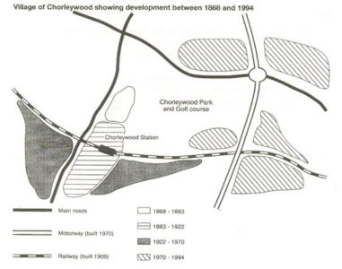
The above figure gives us illustrates how Chorleywood village in London grew in size between 1868 and 1994.
Between 1864 and 1883 there were two main roads, one running in the north-south direction and the other running in the east-west direction. The size of the village was very small. It was located on the eastern side of the main road running in the north-south direction.
Between 1883 and 1922 the village expanded towards the south. A railway line was laid down and the railway station was named Chorleywood station.
From 1922 to 1970 the village expanded around the station. Two new settlements came up around the railway tracks. In 1970 a motorway was built running in the north-south direction and to the eastern side of the village.
From 1970 to 1994 the village expanded further, this time around the motorway. The central part of the village became the golf course and it was named Chorleywood Park.


Leave a reply